Picture this: You’re a buyer in Dallas. You open Zillow on a Tuesday evening, coffee in hand, casually browsing homes in Frisco. Within seconds, one listing stops you cold — a sweeping aerial shot showing a massive backyard, a sparkling pool, mature trees, and the neighborhood park just two streets away. You click. You schedule a showing.
That’s not luck. That’s drone photography doing exactly what it was designed to do.
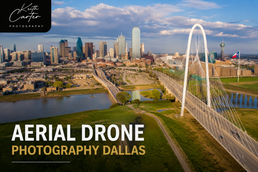
The Dallas-Fort Worth real estate market is one of the most competitive in the entire country. Properties in neighborhoods like Preston Hollow, Southlake, and Highland Park aren’t just sold — they’re marketed. And in 2025, drone photography has moved from being a “premium add-on” to being a baseline expectation for any serious listing.
Here’s why — and what it means for your property.
The Numbers Don’t Lie: What Drone Photography Actually Does for Dallas Listings
Before we get into the how, let’s talk about the why — in numbers.
According to MLS data analyzed across multiple markets including DFW, homes with aerial drone photography sell 68% faster than listings using only traditional ground-level photos. That’s not a marginal improvement. That’s the difference between a listing that sits and one that generates calls within 48 hours.
It gets more compelling:
- 57% of buyers now expect to see at least 8–10 aerial photos in any listing they’re seriously considering
- Buyers are 65% more likely to schedule an in-person showing when aerial photography is included
- Properties with aerial imagery receive 81% more online views on platforms like Zillow and Realtor.com
- In the Dallas market specifically, 61.3% of brokers describe professional photography — including drone — as “crucial” to closing a sale
The Dallas real estate drone services market itself is growing at 18.1% year-over-year, which tells you everything about where agent expectations are heading.
This isn’t a trend. It’s a shift.
Why Dallas Is Different — And Why Drone Photography Fits It Perfectly
Not every city needs aerial photography the same way. Dallas does.
The DFW Metroplex is sprawling, diverse, and geographically complex. A property in Las Colinas sits near major tollways and corporate campuses. A home in Rockwall overlooks the lake. An estate in Prosper has three acres of manicured land and a barn. A townhouse in Uptown Dallas is surrounded by walkable restaurants and nightlife.
Ground-level photography cannot tell these stories. A standard exterior shot shows a front door and a garage. A drone shot shows context, scale, lifestyle, and location — all in a single frame.
Consider a luxury home in Southlake with a resort-style backyard, a tennis court, and a guest house. Ground photos might require 20 different shots to capture all these features — and buyers still won’t understand how the spaces connect. One aerial photograph shows the entire layout instantly, creating an immediate understanding of what makes the property worth its price.
For commercial real estate along corridors like the Dallas North Tollway or I-635, aerial photography becomes even more critical. Potential tenants and buyers need to understand visibility, parking access, proximity to transportation, and the surrounding business environment. A drone can communicate all of that in seconds.
What Professional Drone Photography Actually Captures
Many property owners assume drone photography is just “a photo from above.” In reality, a professional drone shoot captures a layered story about the property that no other format can replicate.
Here’s what skilled aerial photography actually documents:
Full property layout and lot boundaries — Buyers understand exactly what they’re buying. No surprises about lot size, setbacks, or neighboring properties.
Roof condition and architectural structure — Especially important for older homes or properties where roof condition affects value. Aerial images show ridge lines, gutters, chimney placement, and any visible wear — details that build buyer confidence.
Landscaping and outdoor amenities — A pool, an outdoor kitchen, mature oak trees, a fire pit patio — these features define Texas outdoor living. Drone photography shows them in full context rather than cramped individual shots.
Neighborhood and surroundings — Proximity to parks, lakes, schools, and retail matters enormously to Dallas buyers. An aerial shot that includes the neighborhood park two blocks away or Lake Lewisville in the background is doing active marketing work.
Commercial property visibility and access — For retail and office properties, drone shots communicate traffic exposure, parking capacity, and accessibility from major roads — all of which directly affect commercial value.
Twilight Drone Photography: The Upgrade That Outperforms Everything Else
If you want to understand how powerful aerial photography can be, look at the numbers on twilight drone photography specifically.
Real estate listings with twilight photos receive 66% more views than standard daytime listings. When twilight imagery is used as the primary listing photo, views increase by 76%.
The reason is psychological. Evening drone shots capture warm light glowing from windows, illuminated pools, landscape lighting, and — in Dallas — sometimes the glow of the city skyline in the distance. These images don’t just show a property. They sell a feeling.
For luxury properties in neighborhoods like Preston Hollow, University Park, or Colleyville, twilight drone photography creates a cinematic presentation that justifies premium pricing before a buyer even reads the listing description.
The combination of aerial perspective and golden-hour light is, frankly, hard to compete with.
One Thing Many Agents Don’t Think About: FAA Compliance
Here’s something worth knowing before you hire any drone photographer in Dallas.
Commercial drone operations — meaning any drone flight where money is exchanged — legally require FAA Part 107 certification. This is not optional. Fines for unlicensed commercial drone flights can exceed $5,000 under current FAA enforcement guidelines, which tightened significantly in recent years.
Beyond legality, the DFW airspace is genuinely complex. Dallas Love Field and DFW International Airport create controlled airspace zones that require specific LAANC authorization before any legal drone flight. Properties in Addison, Irving, Farmers Branch, and parts of Plano fall within these restricted areas.
When you hire a certified drone photographer, all of this is handled. When you hire someone operating without certification — or attempt a DIY shoot — the risk falls on you.
This is one of the most overlooked factors when agents compare drone photography options. Certifications, insurance, and airspace compliance aren’t bureaucratic details. They’re what separates a professional shoot from a liability.
How to Get the Most Out of Your Drone Photography Investment
Booking a drone shoot is the easy part. Using the images effectively is where many agents leave value on the table. A few practical tips:
Use an aerial shot as your primary listing photo. The thumbnail photo on Zillow, Realtor.com, and the MLS is what drives clicks. An aerial image showing the full property in context consistently outperforms standard front-of-house shots as a thumbnail.
Combine aerial and ground photography in one package. The most effective real estate marketing uses drone visuals to establish scale and context, then interior photography to create emotional connection with the living spaces. They work together — not as substitutes for each other.
Add drone video if you have a timeline. Listings with video receive over 400% more inquiries than photo-only listings. A 60-second cinematic drone flyover posted to Instagram, YouTube, and embedded in the listing creates multiple touchpoints for buyer discovery.
Book your shoot at the right time of day. The best drone photography happens in the two hours after sunrise or the two hours before sunset — what photographers call the “golden hour.” Midday shoots in a Texas summer produce harsh shadows and flat light. The time of day matters as much as the equipment.
Request a virtual tour alongside aerial photography. Research shows that 63% of buyers made offers in 2020 based on virtual tours alone — and that number has only grown. Pairing aerial exterior imagery with an interactive 360-degree interior tour gives buyers the complete picture they need to make a confident decision.
The Bottom Line for Dallas Property Owners and Agents
The Dallas real estate market doesn’t reward average marketing. With inventory levels fluctuating and buyer competition intense across the Metroplex, every advantage matters.
Drone photography is no longer a luxury — it’s an expectation. More than half of active listing agents in the country are already using aerial imagery. In a market as competitive as DFW, the question isn’t whether to use drone photography. It’s whether you can afford not to.
Properties marketed with professional aerial imagery sell faster, attract more qualified buyers, generate more online engagement, and — critically — command stronger offers because buyers arrive with a full, confident understanding of what they’re purchasing.
If you’re preparing to list a property in Dallas — whether it’s a three-bedroom home in Plano or a luxury estate in Highland Park — aerial drone photography belongs in your marketing plan from day one.
Keith Carter Photography provides professional aerial and drone photography services across Dallas, Frisco, Plano, Southlake, Highland Park, and the greater DFW Metroplex. FAA Part 107 certified. Licensed and insured.